QCustomMapView
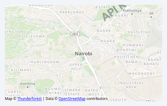
Engine-agnostic map facade.
The facade owns all the STATE (centre, zoom, markers, routes, focus) and a backend renders it. That split is deliberate:
- the state is plain Python and fully testable headlessly, which is what the project plan said a map could not be - it can, as long as the engine is not tangled into it
- the engine can be swapped (QtLocation today, MapLibre/WebEngine later) without touching a line of application code
Every mutation is applied to the state first and then pushed to the backend, so a view created before the engine loads still shows the right thing once it attaches, and a headless test needs no engine at all.
See docs/design/qcustommapview-project-plan.md for why this is an optional extra rather than a core widget.
At a glance
| Tier | Free (GPLv3) |
| Import | from Custom_Widgets.QCustomMapView import QCustomMapView |
| Qt Designer | Code only |
Quick start
from Custom_Widgets.QCustomMapView import QCustomMapView

widget = QCustomMapView()
widget.loadDefaultEngine()
widget.setCenter(-1.286389, 36.817223)      # Nairobi
widget.setZoom(13)
_pump(2.5)
That is the exact code behind the screenshot above.
Dark theme
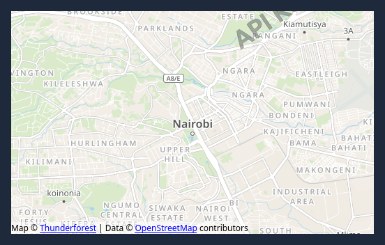
Colours come from the design tokens, so the widget follows the app theme with no extra work.
Properties
Every property below is settable in code and in Qt Designer.
| Property | Type | Default |
|---|---|---|
latitude | float | — |
longitude | float | — |
zoomLevel | float | — |
tileProviderName | string | — |
interactive | bool | — |
Signals
| Signal |
|---|
centerChanged(double,double) |
engineFailed(QString) |
markerClicked(QString) |
zoomChanged(double) |
Methods
| Method | Description |
|---|---|
addMarker(id, latitude, longitude, label='', color='#2563eb', heading=None, icon='') | Add a marker. |
attachEngine(engine) | Attach a backend and replay the current state into it. |
center() | Center. |
centerChanged(...) | Center changed. |
clearFocus() | Clear the focus. |
clearMarkers() | Clear the markers. |
clearRoutes() | Clear the routes. |
engine() | Engine. |
engineFailed(...) | Engine failed. |
fitMarkers(padding=0.15) | Centre on the markers and pick a zoom that contains them all. |
focusMarker(id, glow=True, recenter=True) | Focus marker. |
focusedMarker() | Focused marker. |
hasEngine() | Return whether it has engine. |
interactive(*args, **kwargs) | Interactive. |
latitude(*args, **kwargs) | Latitude. |
loadDefaultEngine() | Load the shipped QtLocation backend. |
longitude(*args, **kwargs) | Longitude. |
mapStyle() | Map style. |
mapStyles() | Style names the engine reports, or [] before it has resolved them. |
marker(id) | Marker. |
markerClicked(...) | Marker clicked. |
markerCount() | Marker count. |
markers() | Markers. |
providerOptions() | Provider options. |
removeMarker(id) | Remove a marker. |
removeRoute(id) | Remove a route. |
route(id) | Route. |
routeCount() | Route count. |
routes() | Routes. |
setCenter(latitude, longitude) | Set the center. |
setMapStyle(index) | Pick one of mapStyles() by index. |
setRoute(id, points, color='#dc2626', width=4.0) | Set the route. |
setTileProvider(provider, **options) | Choose the tile provider. Options are passed to the engine. |
setZoom(zoom) | Set the zoom. |
showPlaceholder(message) | Show why the map is blank, instead of leaving an empty rectangle. |
tileProvider() | Tile provider. |
tileProviderName(*args, **kwargs) | Tile provider name. |
updateMarker(id, latitude=None, longitude=None, **kwargs) | Move or restyle a marker in place. Returns False if unknown. |
zoom() | Zoom. |
zoomChanged(...) | Zoom changed. |
zoomIn(step=1.0) | Zoom in. |
zoomLevel(*args, **kwargs) | Zoom level. |
zoomOut(step=1.0) | Zoom out. |
Runnable example
A complete app using this widget lives at examples/PySide6/QCustomMapView/main.py.